Massive Crack Discovered In The Arizona Desert
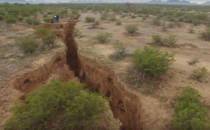
– During a geological survey, drones revealed a massive two-mile-long crack in the Arizona desert.
The 2-mile fissure is located in the Tator Hills. Cracks like these are dangerous. They appear suddenly, swallow entire homes and destroy highways.
There is of course a reason why the crack is now visible.
“These form because the ground is sinking and the ground is sinking because we’re pumping water out and we have for many years,” said Joe Cook of the Arizona Geological Survey has been monitoring the massive fissure in the Tator Hills area since December 2014.
For the first time drones have been sent up to map the gash in the earth, and footage shows humans standing on the edge of the crack, dwarfed in comparison.
“Some areas are about 10 feet [3 meters] across and up to 25-30 feet [7.5 to 9 m] deep (tapering crack, narrowing with depth), while others are a narrow surface crack less than an inch across,” Cook said.
“These narrow sections sometimes have open voids underground, so collapse of the overlying material is possible — this is how the deep open portions of the fissure formed.”
This cracking phenomenon first began in the early 1900s when people began to pump water from the natural, underground aquifers faster than those water reserves could be replenished. In fact, water is being pumped out almost 500 times faster than the aquifers can keep up with.
When the subterranean water in a particular area is all gone, the ground begins to rupture along the edges of these dried up, “alluvial basins.”
It is not the first time a crack like this one appears in the desert. The Arizona Geological Survey (AZGS) has mapped a total of eleven miles of cracks in the desert terrain of the hills since 1977.
However, this new crack is the longest yet recorded in the area.


 Creators of mankind
 Description of “Tall white aliens”
 Where they came from?
 About hostile civilizations
 The war for the Earth
 “Tall white aliens” about eternal life
 Video: “Nordic aliens”
 Aliens
 Alien encounters
 The aliens base
 UFO
UFO Technology UFO
 Underground civilization
 Ancient alien artifacts
 Military and UFO
 Mysteries and hypotheses
 Scientific facts