Ancient Antarctic maps: A telltale sign of Advanced Ancient Civilizations? (Video)
What are the odds of an advanced seafaring civilization(s) existing thousands of years ago, perhaps before the first accounts of written history? Many would say it is just another conspiracy theory, but the truth is that there are several indicators which suggest something like this is entirely possible.
There are clues scattered across the globe which are considered as compelling evidence of a technologically advanced ancient civilization that existed on Earth in the distant past and disappeared –perhaps catastrophically and rapidly— from the face of the planet.
How is it possible that there are ancient maps which are reminiscent of the most accurate modern maps? Incorporating highly accurate longitudes and latitudes? How is it possible that there are ancient cartographic charts which incorporate ‘advanced map projections’ representing spherical world thousands of years ago?
All of this points to the fact that there is a possibility –as Graham Hancock explains— that there are small pieces of a puzzle scattered across the globe, which point towards a very different past in human history than what we have been told.
It has become a popular belief that ancient civilizations across the globe were in fact much more advanced than what mainstream researchers are crediting them for. Numerous maps discovered in the past are clear indications that the story told today by scholars is incomplete, and there are numerous missing links in our history.
Furthermore –and as it is noted by many modern researchers— the existence of numerous ancient cartographic charts – may in fact be a very important indicator that in the distant past, ancient civilizations had an extremely well-developed cartography system comparable in precision to the one we have today.
The existence of numerous maps is considered by many as evidence that ancient mankind knew the exact shape and size of the Earth, contrary to popular beliefs, and used spherical trigonometry, and precise and elaborate mathematical calculations, as if thousands of years ago, an unknown civilization undertook a global-scale project of mapping the entire planet like no one has ever done before.
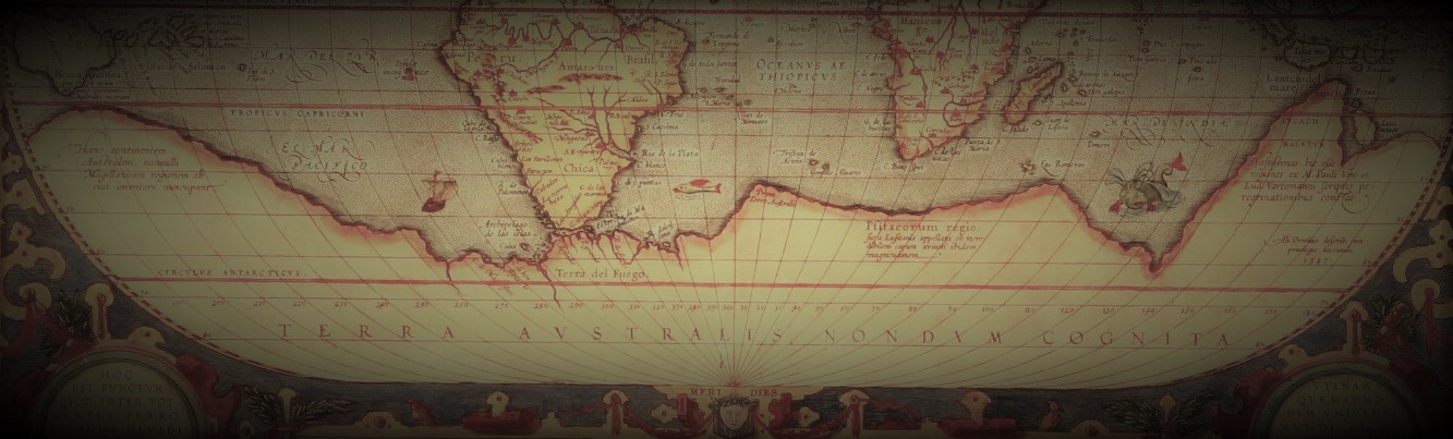
As noted many times in the past, the Piri Ries map is perhaps one of the best pieces of evidence which support this hypothesis.
Composed in 1513, Turkish Admiral Piri Reis created a map that would create a global debate over 500 years after him. The map depicts Antarctica which was discovered between 1818-1820. But how is this possible?
Furthermore, and as noted by Hancock, the Piri Resi map displays advanced mathematics in the map projection, and incorporates highly accurate relative longitudes. The map itself incorporates numerous features that should not have existed in 1513.
However, the mystery behind the Piri Reis map is even greater as the Turkish admiral explained himself on the texts written on the map.
The ancient texts basically say that the maps is NOT his own work and that the Piri Reis map was in fact based on around 20 even OLDER maps. Piri Reis basically put all of the maps together creating the ‘Piri Reis map.’
These so-called source maps have been lost ever since.
However, the Piri Reis map isn’t the only one in existence that reveals shocking clues. The Hadji Ahmed map, which was created in 1559, shows incredibly accurate delineations of the western coast of Northern America and Antarctica. What is even more incredible is the fact that this ancient map shows a land bridge connection Siberia and Alaska, indicating it originated from a time when the bridge was still present
Check out this fascinating documentary and let us know what you think about the Piri Reis map, and whether or not it is possible that thousands of years ago, an extremely advanced civilization existed on Earth.


 Creators of mankind
 Description of “Tall white aliens”
 Where they came from?
 About hostile civilizations
 The war for the Earth
 “Tall white aliens” about eternal life
 Video: “Nordic aliens”
 Aliens
 Alien encounters
 The aliens base
 UFO
UFO Technology UFO
 Underground civilization
 Ancient alien artifacts
 Military and UFO
 Mysteries and hypotheses
 Scientific facts