Satellite images show massive Sahara desert dust plume drifting toward United States
A dust plume from the Sahara Desert is making its way across the globe to the southern United
States, and it’s so big it can be seen from space.
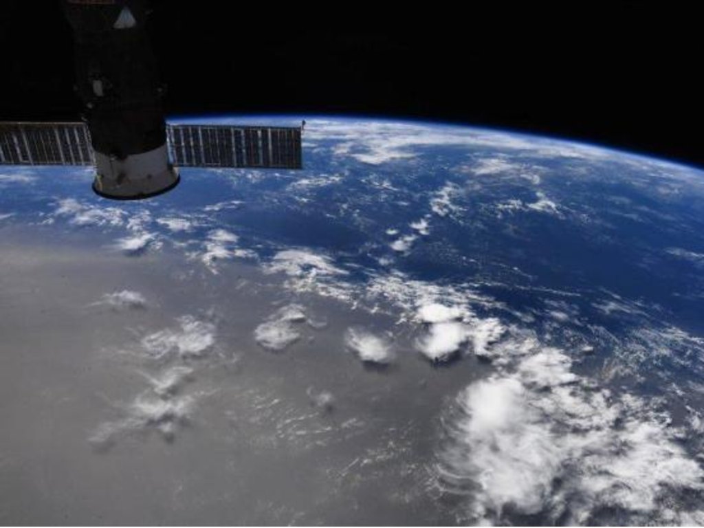
In a satellite photo that NASA astronaut Doug Hurley took from the International Space Station, the hazy brown dust can be seen drifting across the Atlantic Ocean, in juxtaposition to the otherwise blue hue of the planet.
While a plume of this nature isn’t uncommon — in fact, it happens every summer — it usually can’t be seen with such clarity.
This particular plume is the most extreme in recent memory. Dust typically catches a ride with winds travelling east-to-west, but usually breaks up over the Caribbean. This year, the plume is defying the odds by staying intact.
“Normally these dust clouds fan out and disperse as they travel west, but this episode is different as the concentrated layer of dust will remain intact all the way to the Gulf of Mexico and the southeast U.S. in the coming days,” Global News meteorologist Anthony Farnell said.
In a series of before-and-after photos posted to Twitter by @286News, Caribbean skies in Antigua, St. Barts, Puerto Rico and Trinidad and Tobago look very different after the dust hit.
Hurricane tracker Mark Sudduth shared photos from Caribbean island St. Barthélemy, showing clears skies in March compared to very cloudy, dusty skies on Sunday.
Colorado State University’s Cooperative Institute for Research in the Atmosphere (CIRA) shared a mesmerizing time-lapse video on Twitter showing the plume making its more than 5,000-kilometre journey to America.
The National Weather Service (NWS) of the Eastern Region is also tracking the large collection of travelling dust and believes it will hit the southeastern U.S. sometime next week.
But there’s nothing to fear, the organization tweeted. The main impact, it said, will be some especially colourful sunrises.
Aside from beautiful sunrises, people can also expect to see less storm activity in the Atlantic, because hurricanes need hot, humid air, Farnell added.
“The Saharan dust is the kiss of death to hurricane development. The extremely dry air suppresses thunderstorms and prevents tropical storms and hurricanes from forming,” he said. “So don’t expect any storms until the dust settles and that won’t be until July at the earliest.”
Another positive element to the travelling dust is that it can help restore parts of nature that have suffered.
“African dust in the Caribbean Islands and even for the southeast U.S. is a vital source of nutrients for the soil and has even been shown to aid in coral reef development,” he said.
 Creators of mankind
 Description of “Tall white aliens”
 Where they came from?
 About hostile civilizations
 The war for the Earth
 “Tall white aliens” about eternal life
 Video: “Nordic aliens”
 Aliens
 Alien encounters
 The aliens base
 UFO
UFO Technology UFO
 Underground civilization
 Ancient alien artifacts
 Military and UFO
 Mysteries and hypotheses
 Scientific facts