Keeping track of spacecraft as Earth’s water alters its spin
Mass is constantly being redistributed around our planet, as Earth’s atmosphere, oceans and other bodies of water on and under the surface melt, shift and stir. This mass redistribution alters Earth’s center of gravity, which in turn speeds up and slows down the planet’s spin—and so the length of the day—as well as changing the orientation of its spin axis. These changes to Earth’s spin and orientation occur over relatively short timescales of days and weeks, and threaten communication between ground stations and missions in orbit and across the solar system.
ESA is working on its own algorithm to predict Earth’s orientation with extreme accuracy. Early tests show the new ESA algorithm outperforms those being used today from external providers, marking an important step in ensuring Europe’s independent access to space.
The forces at play, changing the day
External gravitational forces, predominantly from the sun and moon, are constantly and predictably acting on our planet. While the sun’s enormous gravity keeps Earth in orbit, the gentle tug of the moon has, over billions of years, quite dramatically slowed its spin, increasing the length of a day on Earth.
When the Earth first formed, a day was somewhere between six and eight hours long and a year would have consisted of more than 1000 sunrises and sunsets.
Closer to home, there are forces at play that have much more rapid and unpredictable effects. Earthquakes, atmospheric winds, ocean currents, and remarkably even human activity itself, all act often and unpredictably to redistribute mass around the planet, altering the speed of Earth’s spin and the orientation of its spin axis.
Conservation of momentum
The ‘conservation of angular momentum’ is a law of physics that explains why a figure skater spinning with her arms out, can suddenly speed herself up by pulling in her arms towards her body.
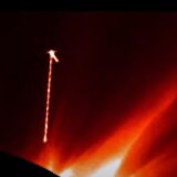
A rarely seen phenomenon: the Earth’s atmosphere bending the light from the full Moon thereby compressing it. Credit: NASA
Earth’s spin too is affected by the distribution of weight around the planet. Earthquakes, remarkably, speed up the spin of our planet in an instant, by rearranging matter through the crust and upper mantle, increasing in a small but not insignificant way the length of the day.
In 2011, a magnitude 9.0 earthquake struck Japan which tragically took thousands of lives and created untold damage. Lasting six minutes, it also shortened the length of the day by 1.8 microseconds (one microsecond = one millionth of a second) and shifted the position of Earth’s ‘figure axis’ – an imaginary line around which the world’s mass is balanced—by about 17 cm. (The figure axis is Earth’s axis of mass balance, while the spin axis wobbles around it.)
Much larger effects are also underway caused by atmospheric winds and ocean currents, as well as the melting of glaciers and the icecaps. As ice melts or breaks off into the ocean, sea levels rise and Earth’s mass is redistributed so it is closer to this central axis, shortening the length of the day.
Such changes are nothing to worry about, unnoticeable to our day-to-day lives. But when it comes to flying spacecraft across deep space, or keeping in sync with satellites in orbit, these tiny changes can mean the difference between finding and losing your mission.
Holding on to ESA missions
To fly ESA missions, the Agency is dependent on what are called Earth orientation parameters (EOPs), which describe the irregularities in the rotation of the planet. If you dont know them, you have a real problem.
“Our ground stations are in communication with interplanetary spacecraft millions of kilometers away. They need to be pointed with extreme accuracy to target these relatively tiny objects,” explains Werner Enderle, Head of ESA’s Navigation Support Office based at the Agency’s ESOC Operations Center in Darmstadt, Germany.
“One degree on Earth equates to thousands of kilometers in space, so if you don’t have accurate values for Earth’s orientation, you can be off by a long way.”
Getting these parameters requires a huge amount of work analyzing the cumulative effects of the weather, climate change and geological activity. Because these systems are so complex, we can currently calculate the changes in Earth’s orientation on relatively short timescales, weeks and months ahead.
A map of the terrain displacement based on Envisat Advanced Synthetic Aperture Radar of the earthquakes that struck Japan beginning on 11 March 2011. The map is derived from an interferogram generated by INGV using data acquired on 19 February and 21 March 2011 on track 347. The map shows a large portion of the surface displacement field. The maximum displacement along the Line Of Sight (of the satellite) reaches about 2.5 m relative to a reference point within the entire frame strip located nearby the southern boundary. Credit: Based on ESA data -The Istituto Nazionale di Geofisica e Vulcanologia (S. Stamondo, M. Chini and C. Bignami)
ESA determines Earth’s orientation
Currently, these vital parameters are provided by the United States Naval Observatory (UNSO), based on contributions from Institutions around the world including ESA. However, ESA is working on determining its own EOP values, ensuring Europe’s independent access to space and removing dependency on an external provider. These orientation values, computed by a team at the Navigation Support Office, will be made freely available around Autumn this year.
The tool estimates and predicts Earth’s orientation and rotation up to 90 days in advance using space-based measurements from global navigation satellite systems (GNSS) and satellite laser ranging among others, an area in which the office has a great deal of expertise.
“Our algorithm uses atmospheric and weather conditions, seismic activity, the rate at which sea levels are rising and Earth’s ice is melting and a host of other variables, all of which interact in complex and hard-to-predict ways,” explains Erik Schoenemann, Navigation Engineer at ESOC who leads the project.
“It’s easy to take these values for granted, but all spaceflight activity relies on them and a huge amount of work goes into getting them. We are really happy to now have our own source of this data, securing our ability to conduct complex missions in different orbits and to receive the incredible data they send home.”
So far, early tests show the new ESA algorithm significantly outperforms those currently in use, marking an important step in ensuring Europe’s independent access to space.


 Creators of mankind
 Description of “Tall white aliens”
 Where they came from?
 About hostile civilizations
 The war for the Earth
 “Tall white aliens” about eternal life
 Video: “Nordic aliens”
 Aliens
 Alien encounters
 The aliens base
 UFO
UFO Technology UFO
 Underground civilization
 Ancient alien artifacts
 Military and UFO
 Mysteries and hypotheses
 Scientific facts