Major 8.2-Magnitude Earthquake Rocks Alaska
8.2-magnitude earthquake
According to the USGS Alaska Earthquake Center, an 8.2-magnitude earthquake struck off the Alaskan peninsula late Wednesday, July 28, 2021. It struck at 10:15 p.m. local time Wednesday (6:15 UTC on July 29). An 8.2-magnitude quake is a very powerful earthquake. This one prompted a tsunami warning for parts of Alaska and Hawaii. But – although tsunami warning sirens sounded across Alaska’s Kodiak island (population about 6,000) – large tsunamis did not strike. And there are no tsunami warnings in effect at this time. The earthquake struck about 65 miles (104 km) southeast of Perryville, Alaska, USGS said. Perryville is a small village about 500 miles (800 km) from Anchorage, Alaska’s biggest city.
The U.S. Tsunami Warning System initially warned of hazardous waves. But, about two hours later, it provided an update that the forecast maximum height of any tsunami would be less than one foot (30 centimeters) above tide levels.
The earthquake left multiple aftershocks in its wake. They were recorded within 90 minutes of the main earthquake. The largest had a magnitude of 6.1, according to the USGS.
Did you feel it? Tell USGS
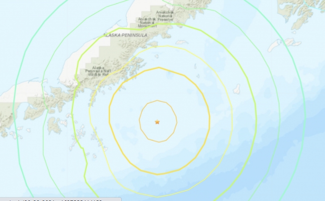
A map showing light to moderate shaking at the earthquake’s epicenter, but almost no shaking at Anchorage, 500 miles to the north.
View larger. | The “shake map” for the July 28-29, 2021 Alaska earthquake, via USGS.
Pacific Ring of Fire
Alaska is located along the Pacific Ring of Fire, which is a horseshoe-shaped region around the Pacific Ocean, where most of Earth’s volcanoes and earthquakes are found. If you could view it from space, the Ring of Fire would appear as a strip that runs up the western coasts of South America and North America, continuing across the Alaskan Aleutian Islands to Russia’s Kamchatka Peninsula. Then, it heads south, off the coast of Eastern Asia, passing through Japan. At Southeast Asia, it jogs eastward through the Indonesian islands of Sumatra and Java, past Papua New Guinea, then southward again to New Zealand.
USGS explained more about Alaska’s location along the Ring of Fire:
The Aleutian arc extends approximately 3,000 km from the Gulf of Alaska in the east to the Kamchatka Peninsula in the west. It marks the region where the Pacific plate subducts into the mantle beneath the North America plate. This subduction is responsible for the generation of the Aleutian Islands and the deep offshore Aleutian Trench.


 Creators of mankind
 Description of “Tall white aliens”
 Where they came from?
 About hostile civilizations
 The war for the Earth
 “Tall white aliens” about eternal life
 Video: “Nordic aliens”
 Aliens
 Alien encounters
 The aliens base
 UFO
UFO Technology UFO
 Underground civilization
 Ancient alien artifacts
 Military and UFO
 Mysteries and hypotheses
 Scientific facts